
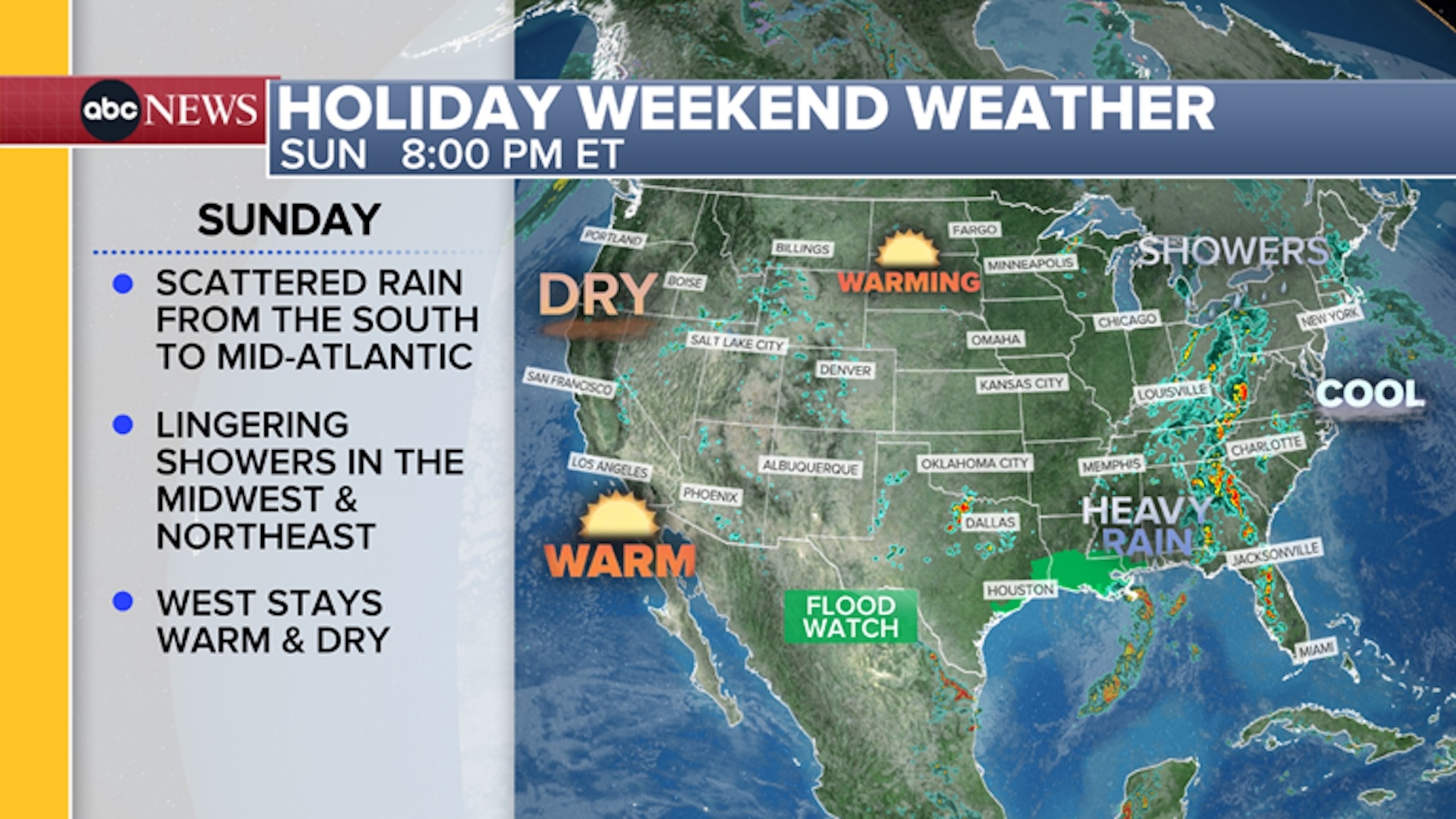
A soggy weather pattern will continue to plague the eastern half of the nation on Sunday with wet and cool conditions, but some improvement is in store for the Northeast and Midwest leading into Memorial Day.
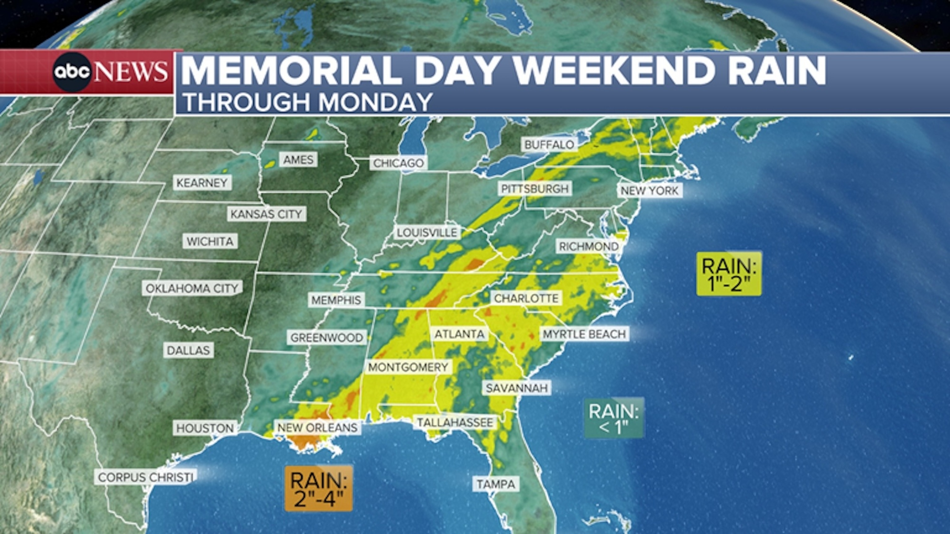
Flood watches have been issued from southeastern Louisiana into Mississippi, Alabama, Georgia, Tennessee and West Virginia – including the cities of Atlanta, Baton Rouge, Birmingham, New Orleans, Knoxville and Charleston – for heavy rain through Memorial Day.
A widespread one to two inches of additional rain is likely from southern Louisiana up to the Carolinas, with pockets of two to four-plus inches possible with the heaviest downpours.
Anadolu via Getty Images
Some of these storms could also be strong enough to produce gusty winds as well as some small hail.
The rainy weather is causing some flight delays on Sunday at airports, including O’Hare International Airport in Chicago.
ABC News
The Federal Aviation Administration issued a ground stop at O’Hare International Airport in Chicago Sunday morning due to thunderstorms. Arriving flights at O’Hare were experiencing average delays of 44 minutes, according to the FAA. Flights scheduled to depart from O’Hare were experiencing delays of up to one hour and 45 minutes, according to the FAA.
ABC News
Thunderstorms forecast for central Indiana on Sunday afternoon could interrupt the 110th running of the Indianapolis 500 at the Indianapolis Motor Speedway. The race got underway around 12:45 p.m. ET but a thunderstorm caused a brief suspension of the race in the 106th lap.
The National Weather Service office in Indianapolis is forecasting a chance of isolated showers and thunderstorms throughout the afternoon.
Memorial Day forecast
Scattered rain and thunderstorms continue to linger in the South for Memorial Day.
In the Northeast, warmer and drier conditions will gradually sweep from west to east across the region throughout the day. Morning rain closer to the coast will likely clear out by the afternoon in most spots.
Some sunshine could reach the I-95 corridor later in the day.
Highs will be in the 80s from Chicago to Minneapolis for Memorial Day, with afternoon temperatures on Monday forecast to be back into the 70s across much of the Northeast, including in Washington, D.C., and New York City.
Mostly dry and warm conditions will be in place for most of the Midwest for the holiday, with highs expected to be in the 80s from Chicago to Minneapolis.
A few scattered morning showers are possible from Iowa to the western Great Lakes, but temperatures are expected to warm up across the Plains with highs reaching the 90s in Montana and North Dakota.
Much of the West remains warm and dry with the exception being parts of the Pacific Northwest as rain moves in by Monday afternoon across western Oregon and Washington, including the cities of Portland and Seattle.
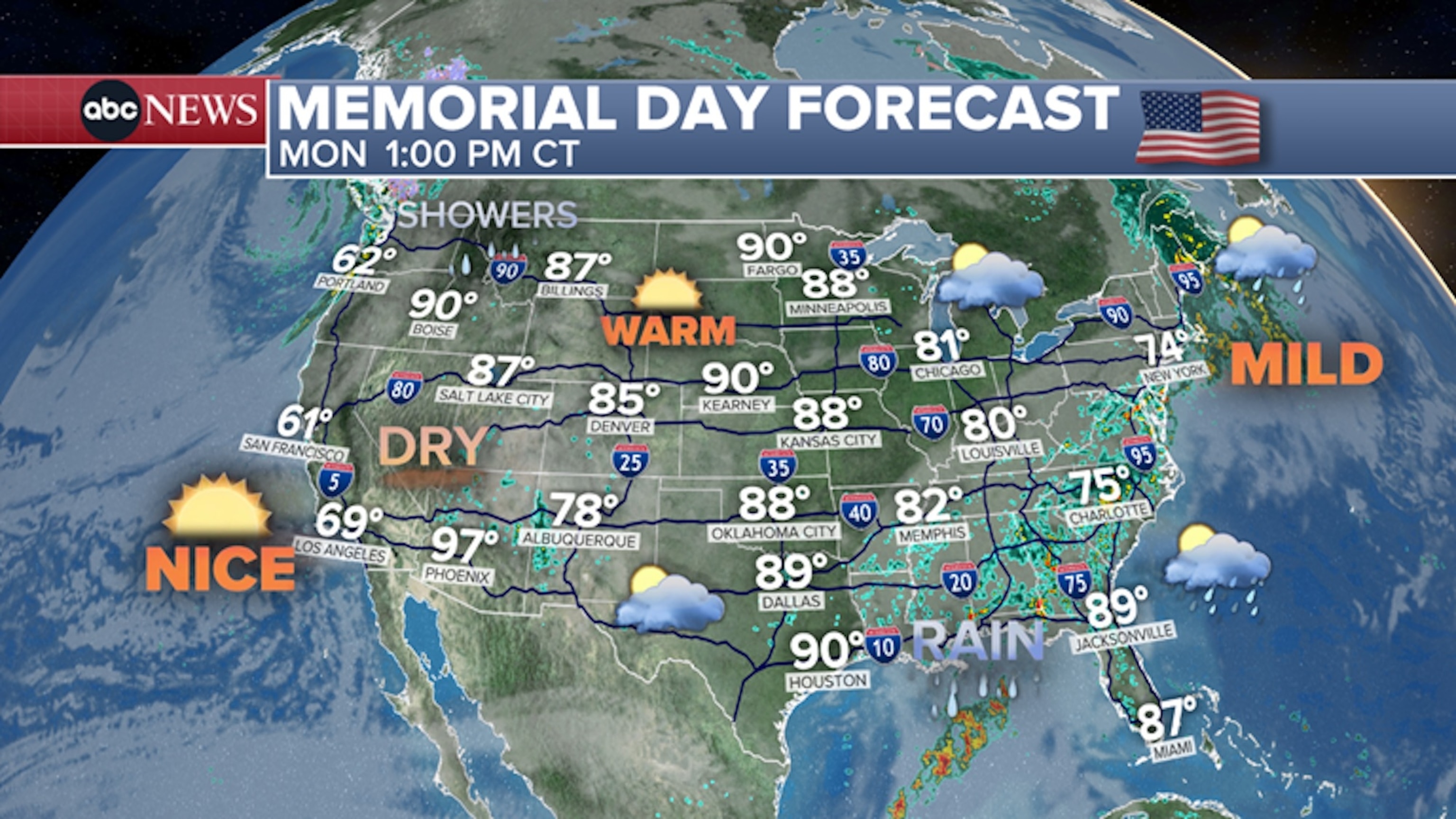
Memorial Day forecast.
ABC News
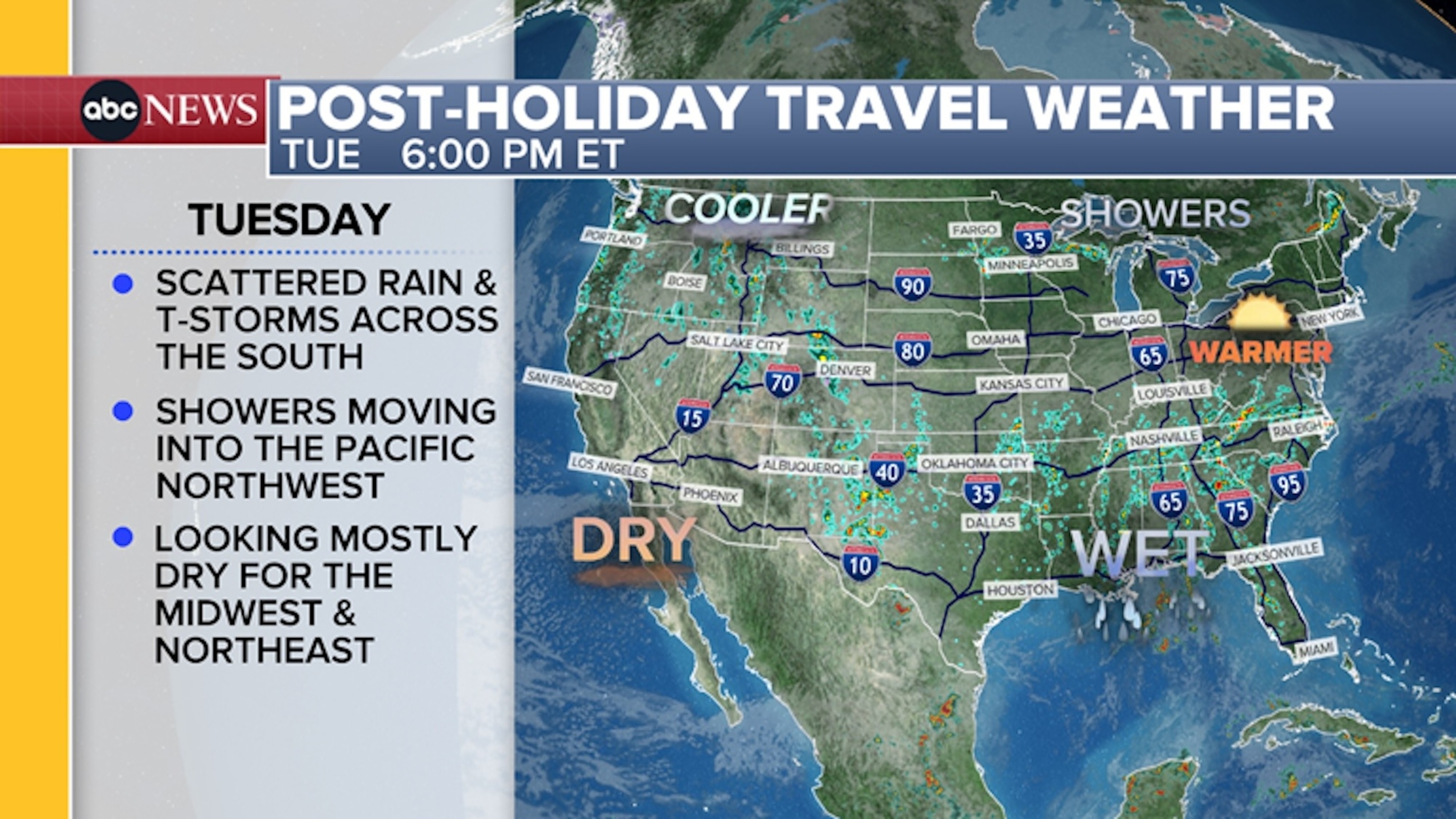
Post-holiday forecast
For folks going back to work or school or making their way back home from the holiday weekend, the South will continue to see scattered rain and thunderstorms into the new work week. This may cause some minor travel hiccups for those traveling by plane and some slippery conditions for drivers.
Post-holiday travel weather.
ABC News
The Northwest will see some clouds and showers move into the region and begin to spread into the intermountain areas of the West later on in the week, but it won’t be a complete soaker.
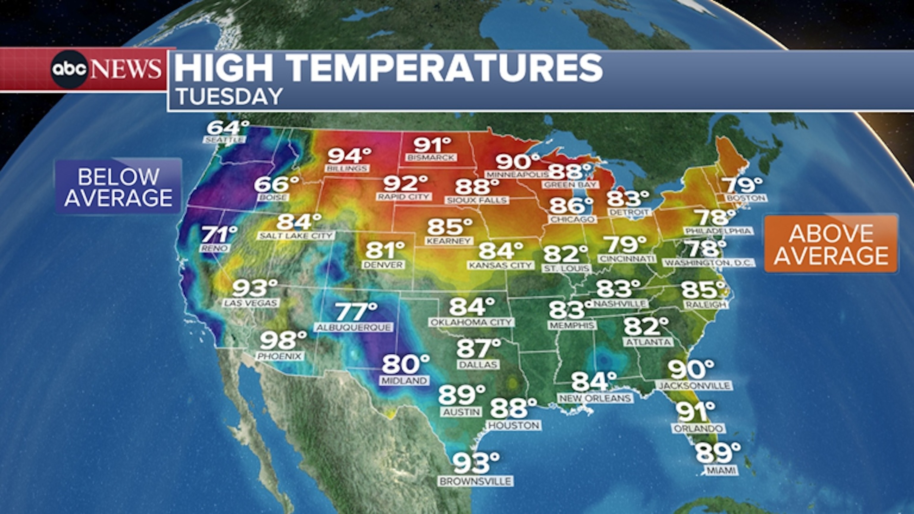
Post-holiday temperatures.
ABC News
This will also usher in noticeably cooler temperatures for much of the West for Tuesday into Wednesday, with highs going from the 70s and 80s for most of Monday down into the 60s and barely reaching the 70s on Tuesday and Wednesday.
Meanwhile, a warming trend will continue into the middle of the week across the Northeast on Tuesday. Afternoon highs will be near 80 degrees from New York City to Boston by Tuesday.


